
Day 73. July 18, 2019. Old State Hiway in Idaho
Podcast episode #16 Transcript
Dougie, Billie, and Craig
7/18/20199 min read
Hey everyone...Welcome Back! It's Day 73...it's also 7/18/2019. And we found a place called....Old State Hwy
Sometimes Google maps gets it very, very right…even if completely by accident…
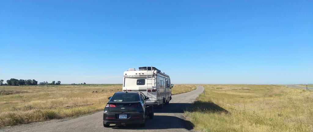
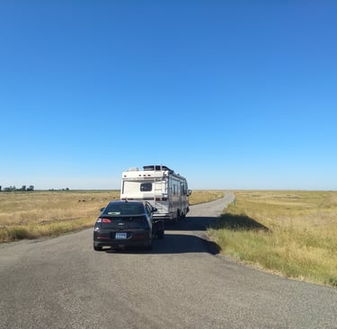
Left Fairfield early this morning....we did a quick stop for gas in a place called Carey. As we turned right and headed out hiway 26…Sawtooth Mountains in the rear view…I pulled up Google Maps…destination Cokeville Wyoming. Figured that is as good a spot as any to consider the downward turn towards Colorado….so why not squeeze a little Wyoming into the drive. A few minutes into the drive the nice lady in my phone instructed me to take a left onto Old State Hwy then immediately turn right…so I did make that left hand turn.....but the immediate right?
Here's the cool part....what she had instructed me to do was taking us off of the main highway....and onto an obviously very old road that was barely even asphalt anymore....in many spots....it was gravel....and dirt....obviously decades of neglect had allowed mother nature to begin reclaiming the land once the newer highway we had just pulled off of was put through the area. If we had taken that immediate right.....the aging Old State Hiway would have simply, and nearly immediately, returned us to the hiway we had just exited.....so guess who didn't take that immediate right?
We sat there for a few minutes wondering what might lie ahead....if we went straight. How far in would in would we get before the aging asphalt had completely surrendered to time and we were on a dirt road....if there were even a road...or trail left....would it be passable....would there be a place to turn around.....things were pretty dry....but could we get stuck? Well.....one way to find out.....and straight ahead we went. Slow going....some 10 to 15 miles an hour or less....until hiway 26....and the occassional semi's using it.....were nothing more than a spec on the horizon to our right. I would guess that we were some 3 or 4 miles out when we came to a crossing. It was clear that if we went right....we would likely traverse the same type of road we had just passed over....back out to the main hiway. To the left...who knows....that trail.....which is essentially what we were on at this point.....meandered up and through the rolling hills seeming as if to wind it way back into the surrounding mountain ranges....and straight ahead....again....who knows....another trail that appeared to go on forever. Studying where we were sitting....and the scenery....I pulled into the crossing and swung a wide turn coming back around and were once again facing the main hiway in the distance....and turned off the RV. I'd glanced at the clock and it was coming on 10:30 in the morning....close enough to lunch for me.....and at this particular point in time....I could not imagine a better place to spend a few hours in the foothills of the sawtooth mountains.....learning.
First up....you guessed it...a walk with boys. Lets go check this place out. We'd spend the next few minutes walking up the road a ways in each direction....looking to see what might be just up over that next horizon.
Back at the RV....I'd fire up the generator and check the fridge....and quickly realize I was a bit over due for a stop at the grocery store. My options......ham sandwhich and a glass of water......or a plate full of pizza rolls and a beer.
15 minutes later....the boys were tethered in outside while dad lounged in the folding chair soaking in the scenery of the Sawtooth Mountains of Idaho.....while polishing off a platefull of pizza rolls and an ice cold coors light. Remember what I said about time fading away out here......the sun had been up for hours....and so had we....and....it's 5 oclock somewhere.
With lunch handled....I poked away on the laptop switching between reading....watching video's...and mostly....just staring....at what was all around us....history. I'd find myself staring at the broken down asphalt road and cinamatizing the last 70 years or so....cinamatizing? Is that even a word? Spell check didn't correct it?....so basically.....I was making movies in my head. What had gone into this land ..... and what had left this land....in a matter of some 6 or 7 decades.
Dusty trails like this one....trekked for decades by folks on horseback and in wagons .... would be transformed all across the country....into smooth surfaced....asphalt roads ....once Henry Fords Model A....and then Model T would transform transportation across the country .... and globe for that matter....drove the need for a smoother and more passable surface road. Progress would move so rapidly that within just years of a road like this ones installation.....a more direct...wider...and faster route would render these roads like where I sit right now nearly useless. Left alone....unused.....and deteriorating back into the earth it had once attempted to cover up and smother out. Studying how the cracks in the asphalt that had begun so simply....the native plants of the area seeding and growing through the once inpenitrible surface...broadening the cracks...speeding up the decay and turning this man made thing called asphalt back into dirt. Mother nature....once again...taking back what was hers....
Here's a fun fact....the first road constructed...in history....would be around 2600 to 2400 bc in Egypt.....when folks had to figure out how they were going to move 4000 pount blocks of limestone from the quarry where they were being mined....to the building site of the Ancient Pyramids of Egypt. The brainiacs of the time had determined that if they somehow built a smoother surface across the top of the sands of the area's desert...this would enable them to place logs under the huge blocks of stone and essentially "roll" them from the quarry's to the building sites...some 7 miles away. A combination of sandstone and limestone blocks....along with wood was used to accomplish this. And there ya have it...one of the 7 wonders of the world and the first road ever constructed.
Hmmmph...so I'm having a think through that for a second....what that must have looked like....road construction some 4000 years ago....compared to today. Probably....the next time I roll up on a stretch of highway that has been shut down to one lane.....and I hold my place in line waiting for that gal...or guy...in the orange vest to speak into the walkie talkie app on their cell phone.....then flip the sign in their hand from stop....to slow....I'll probably just be greatful that I am not waiting for some 200 or so men (oh...and throw in a few camels) to shuv a 2 ton block of limestone up that section of closed road on a sled type thingy on logs enabling them to roll it .....stopping every so often to pour water on everything...cause you know....that stuff's gotta cool down.
And from picturing through how roads were installed and forgotten......my gaze would shift to the downed fencelines that peppered the landscape. And again...another movie starts playing in my brain....I can hear the shovels and pick axes digging holes...so that 6 ft rough cut...square....pieces of lumber could be buried 2 feet into the ground. The sweat...the DNA dripping into the soil on a hot summer day while this process would be completed every 8 to 10 feet....for miles. So that these dreamers could then come back through and string a fenceline within which to claim their land...and begin farming...ranching...living.
And today...as I sit here....what was all that sweat for? Where did they go? Where did whatever that fence once contained go? A few rotted sticks and rusty barbed wire lying on the ground says that they were here....and that they worked hard to be here...but they are gone....and just like all those places we had seen across eastern Oregon....Hardman....Unity....and beyond....abandoned....and left to history?
Thoughts and wonderings would shift countless times on this perfect early summer day on a prairie at the base of the Sawtooth Mountains. The cool summer breezes continuously shoving the Bartonberry shrubs back and forth as they dig their roots deeper into the soil beneath whats left of that asphalt....each grow cycle making the plant only stronger...while making this once brand new road...a thing of the past....
The bitterbrush bobbing in the same breezes while Bluebunch Wheatgrass sways softly as a backdrop to it all....all the while shifting from shades of green to even light blues in the early afternoon sun. And throughout all...the vivid colors of the cannas blossoms that no doubt exploded on the scene in early spring announcing their arrival in a brilliant purple bud....have now faded...shifting to green and brown as they prepare to lay down for another summer...only to return with a vengance again next spring....it's too bad...I thought...I wont be here to see that.
All this activity.....all at once...and yet...singularly ... all around us.
Then my gaze would shift....up....and into those sawtooth mountains. I had to know more.....whats out there....what used to be there....how did "there" even happen?
Studying the jagged, serrated looking edges of the rugged peaks make it easy to understand the name of the granite rock mountain range.
The Mountain Range itself cuts through central Idaho some 43 miles from North to South....spanning 4 counties and nearly 680 square miles...and is actually part of the Rocky Mountain Range. At it's highest elevation you will find Thompson peak at nearly 11 thousand feet....with the average elevation throughout the range being around 7500 feet.
Formation of the mountain range can be traced geolocially back some 60 or 70 million years when the area was actually part of a vast interior seaway called the Western Interior Seaway. This seaway would extend from present day Gulf of Mexico...to the Arctic Ocean....dividing the continent into east and west land masses. Fossil discovery tells us that these shallow seaways teamed with life including amonites, sharks, and many forms of marine reptiles...Imagine...sea dwelling sharks...in Idaho.
Geological ativity in surrounding areas including Canada, Utah and Nevada would begin some 120 million years ago with the formation of mountain ranges in these areas. While the sawtooth range were not yet a part of the landscape...it is this techtonic activity around it that would set the stage for their formation.
Over millions of years...the North American Plate would continue to drift westward....throw in some tectonic, and volcanic activity...and the area would begin to rise up out of the sea.
Somewhere between 2.5 million....to as recently as 100,000 years ago...Glacial and Ice sheet activity in the area would begin to play a major role in shaping this iconic Mountain Range.
At around a million years ago...the area would experience a prolonged colder climate....during which the higher elevations would play host to massive glaciers....at one point these glaciers would cover nearly 1 third of what we call Idaho.
This glacial erosion would carve out u shaped valleys in which glacial lakes would form numbering in the thousands....and are still present today.
The activity would also leave behind deep valley areas along with the narrow ridges of rock that separate these valleys which create the shapes...rugged and jagged peaks that the range is known for.
Like so much of the region....the area is home protected Wilderness Areas....along with plenty of national forest area's that provide an abundance of outdoor activity oportunities.
Also learned that the area remains a very siesmicly active as well....up thru modern day. An Area called "Garden of the Giants" can be explored via a hike up from RedFish Lake. This area very graphically examples rock slide activity in the area in which massive boulders are shaken loose during earth quake activity relocating themselves in various spots down the jagged moutainsides. You can even see massive craters in the mountain sides where Boulders impacted the earth on their fall down from the cliff's above. Rock Slide activity can also be the result of sections of granite hillside will weaken during the extreme freeze and thaw cycles of the region....weakening them to the point of failure in isolated areas. Pretty awe inspiring to think about how the forces of nature have worked for millions of years to create a literal work of art....and those forces are still at it today.
National Geographic once said that "Life unfolds on a road trip....and you do not have to travel the world to find natural beauty....it's usually in your own back yard" And today...sitting here in the foothills of the Sawtooth National Forest...in Idaho...I'm realizing that I'm in the middle of all this natural beauty. And it is in somebody's backyard. Who's backyard? I dunno. Likely countless have called this place their backyard over the decades and centuries...but today....On July 17th 2019...for about 5 hours....it was my back yard. And I ...... am loving my backyard right now.
A few hours later I started packing up....getting ready to trek back out to the hiway when a pick up rolled up the road slowly along old state hiway....trailer in tow with two side by sides on it. This would be the only vehicle we had seen out during our entire stay. They rolled by slowly .....waving.....giving us a curious look.....they didn't stop....but it was clear an RV sitting out here in the middle of nowhere is not something they saw every day. It was also clear that they were headed out into the area for an afternoon and evening of fun...exploring this incredible area on their side by sides...
We would make our slow trek back out to the hiway...hang a left and continue on. We wouldn't get very far when I saw a sign that read..."Peaks to Craters Scenic Biway" We already know I'm a sucker for a scenic biway....but then I read....Craters of the Moon.....Craters of the Moon....
Hah......I wonder what we'll learn there??